The altitude of an aircraft is one of the most important indications in the cockpit. There are two main methods of altitude measurement. The primary measurement for altitude of an aircraft comes from a pressure altimeter. A pressure altimeter can sense ambient pressure and convert it into an altitude.
The workings of a Pressure Altimeter
In its simplest form, a pressure altimeter is a barometer that senses ambient pressure. This pressure is called static pressure, and it is measured using a sensor mounted outside the aircraft, which is known as a static port.
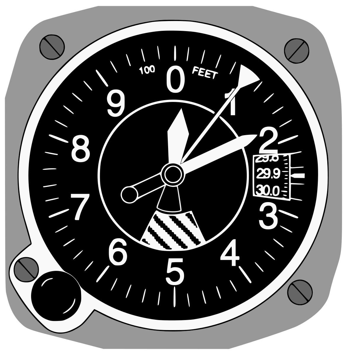
As the altitude increases, the pressure decreases, and as the altitude decreases, the pressure increases. In a basic analog altimeter, there is a capsule that expands and contracts with changes in pressure. This expansion and contraction are then translated into a rotational movement of an indicator pointer in the instrument using a mechanism.
When the pressure inside the instrument decreases (in a climb), the capsule contracts and moves the pointer clockwise, showing an increase in altitude. When the pressure increases (in a descent), the capsule expands, moving the pointer anti-clockwise, showing a decrease in altitude. The simple altimeters have indications of altitude in feet. There are three pointers in such an instrument: a 100 ft pointer, a 1,000 ft pointer, and a 10,000 ft pointer.
In modern aircraft, the altitude is given in digital displays. The static pressure is fed to an Air Data Computer, which then computes the altitude and displays it to the pilots.
The different pressure settings used by the altimeter
The altimeter needs to be fed the correct pressure data before it can be used to accurately determine the altitude. There are different pressure data under which the altimeter works.
The QFE
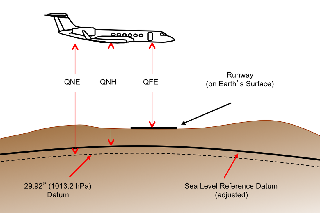
QFE is the pressure at the airport or aerodrome. When QFE pressure is set by the pilot in the altimeter, the altimeter reads zero because it uses the airport pressure as the reference to calculate the altitude.
The QNH
The QNH is the pressure referenced to mean sea level (MSL). This pressure is calculated based on ISA (International Standard Atmosphere) conditions. The ISA conditions consist of a surface temperature of 15 degrees Celsius, a density of 1.225 kgm-3, and a pressure of 1013.25 hectopascals (hpa). When QNH is set in the altimeter, it reads the airport elevation above the Average Mean Sea Level (AMSL). For example, if the airport is above 500 ft above sea level, when QNH is set on the altimeter, it should read 500 ft when on the ground.
The QNE
QNE is known as the pressure altitude. It is the vertical position of the aircraft when the standard 1013 hpa is set in the altimeter subscale.
The easiest way to understand the difference between QNH and QFE is to work out a simple example.
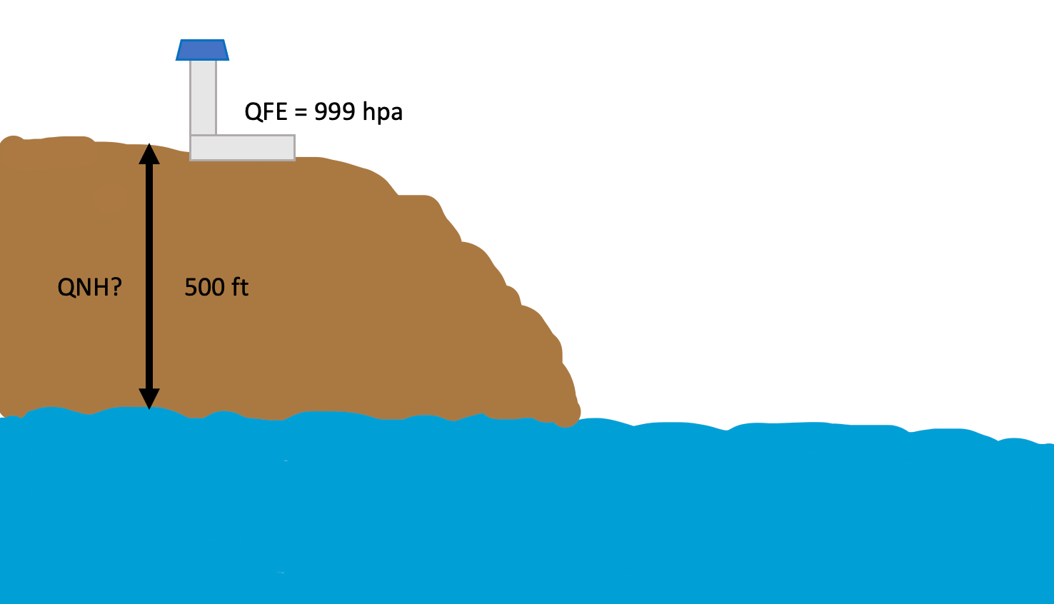
Let us say there is an airport, and at midday the QFE (airport pressure) was reported to be 999 hpa. If the airport has an elevation of 500 ft above AMSL, what is the QNH? (Assumption: With every 1000 ft increase in altitude, the pressure decreases by 27 hpa).
To find the QNH:
1000 ft ---- 27 hpa
500 ft ---- x
x = 13.5 hpa
This means that the pressure changes by 13.5 hpa with a 500 ft altitude change. We know that the airport pressure is 999 hpa. So, the QNH (AMSL pressure) is equal to 999 + 13.5 = 1012.5 hpa.
So, if the pilot sets 1012.5 hpa on the altimeter, it would indicate 500 ft on the ground. If 999 is set, the indicated altitude will be zero.
How pilots use the pressure altimeter
At the start of the flight, the pilots get the latest QNH from the airport weather services. This either comes from the Air Traffic Control or the ATIS (Automatic Terminal Information Services). The pilots then set the QNH on the altimeter subscale. This QNH is known as the local QNH.
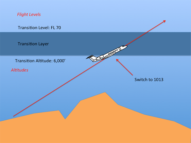
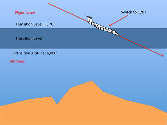
If you think about it, there is a small problem with this. The local QNH is the local QNH and different aircraft flying out of different aerodromes will have different local QNHs. To solve this issue, at a certain altitude, all airplanes switch from flying with the local QNH to flying with the standard ISA QNH, which we know is 1013 hpa. This changeover happens when the aircraft passes through the transition altitude. Similarly, when an aircraft descends, it changes over to the local QNH of the airport it is going to land. This occurs when the aircraft passes through the transition level. Now, let us have a look at the definitions of transition altitude, level, and transition layer.
Transition altitude
The altitude at or below which the vertical position of the aircraft is given in altitude using the local QNH. For example, if an aircraft departs Heathrow Airport with a QNH of 1008 and climbs to 5,000 ft, we should say that the aircraft's altitude is 5,000 ft.
Once past the transition level, the altimeter scale is changed to 1013, and from that point on, the vertical position of the aircraft is given in flight levels. For example, if the transition altitude of Heathrow Airport is 6,000 ft, with the aircraft out of 10,000 ft, the correct way of saying its altitude is flight level 100 or FL100 for short.
Transition level
This is the lowest level available to use above the transition altitude. Once the aircraft passes this level, the local QNH is set on the altimeter.
Transition layer
This is the airspace between transition altitude and transition level.
The altitude and level for transition is decided by the airport depending on the obstacle clearance. In some countries like the USA, the transition is fixed at 18,000 ft. In some countries, the transition level can be as low as 4,000 ft.
There are various checks of the altimeter before and during the flight. The altimeter is an important instrument when flying in RVSM airspace, and it must be within a certain level of tolerance. On the ground, with the correct QNH set, the altimeter must be able to read the elevation of the airport within 75 ft and the difference between the captain’s and first officer’s altimeter should not exceed 25 ft.
The errors associated with pressure altimeters
As an altimeter is an instrument, it suffers from various errors.
The first type of error we will look at is called the position error. The position error is an error caused by the static source. The positioning of the static port leads to this error. For instance, if the static port experiences low pressure due to the way air flows over it, it can give false pressure data to the altimeter. The aircraft manufacturers try to minimize this error by placing the static source in parts of the aircraft where pressure peaks are at their lowest. And in test flights, they use trailing cones to measure undisturbed static pressure to calibrate the air data computers.
The main type of error experienced by all altimeters is the temperature error. As previously discussed, pressure altimeters are calibrated in ISA conditions. This means if the conditions such as the temperature deviate from the ISA, the altimeter cannot give the actual altitude of the aircraft. The temperature is important because it affects pressure, and a change in pressure affects the altimeter.
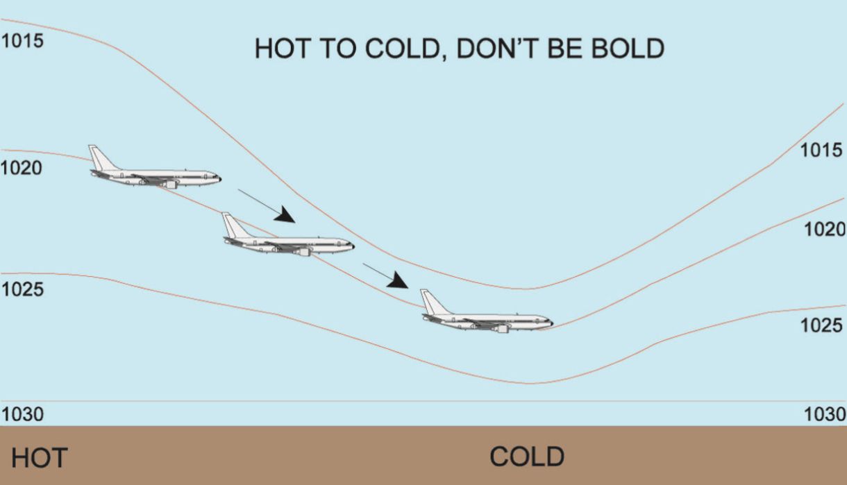
In cold conditions, the pressure lines (isobars) compact or comes closer to each other, and in hot conditions, the lines of pressure expand and move far from each other. This means when in cold weather, the altimeter overreads, and in hot weather, it under reads. Thus, there is a reason to differentiate between True Altitude and Indicated Altitude. The true altitude is the real altitude that is corrected for temperature, and the indicated altitude is the one shown on pilot instruments.
When flying from hot conditions to cold conditions, failing to understand the difference between true altitude and indicated altitude can lead to a disaster. There is a pilot jargon for it. "When flying from HOT to COLD, DON'T be BOLD!"
The indicated altitude can be corrected for temperature mathematically, given that for every degree Celsius deviation from ISA, the height correction is 4 ft per 1000 ft. We can work out an example. If the temperature at some place is -30 degrees Celsius and the indicated altitude is 5000 ft, what is the true altitude?
ISA temperature at 1000 ft is = 13 degrees Celsius (-2 degrees per 1000 ft)
ISA deviation is = (-30) – (13) = -43 (43 degrees below ISA temperature)
4 ft per ISA deviation = 4 x (-43) = -172 ft
1000 ft ---- -172 ft
5000 ft ---- x
x = -860 ft
So, the true altitude of the aircraft is = 5000 ft – 860 ft
= 4140 ft
As you can see, a reduction in temperature can make the pilot feel that he/she is higher than he/she is. In our case, the difference between true altitude and indicated altitude is almost 1000 ft which unchecked can result in contact with terrain.

.jpg)
.jpeg)
.jpeg)
Air-France-A220.jpg)
